DroneSentry-C2
Command and Control Platform - On-Prem or Cloud Based
On-Premises Item Number: 407 | Cloud Item Number: 408
DroneSentry-C2 Command-and-Control (C2) provides an intuitive and feature-rich software platform, providing counter-UAS awareness and reporting capability. It integrates both DroneShield and third-party C-UxS sensors and effectors. Those include multiple AI-enabled sensing and tracking products, such as:
RfOne: long-range direction-finding sensors for UAS detection and tracking
DroneOptID: camera-agnostic optical/thermal camera AI software
SensorFusionAI: sensor-agnostic, 3D data fusion engine
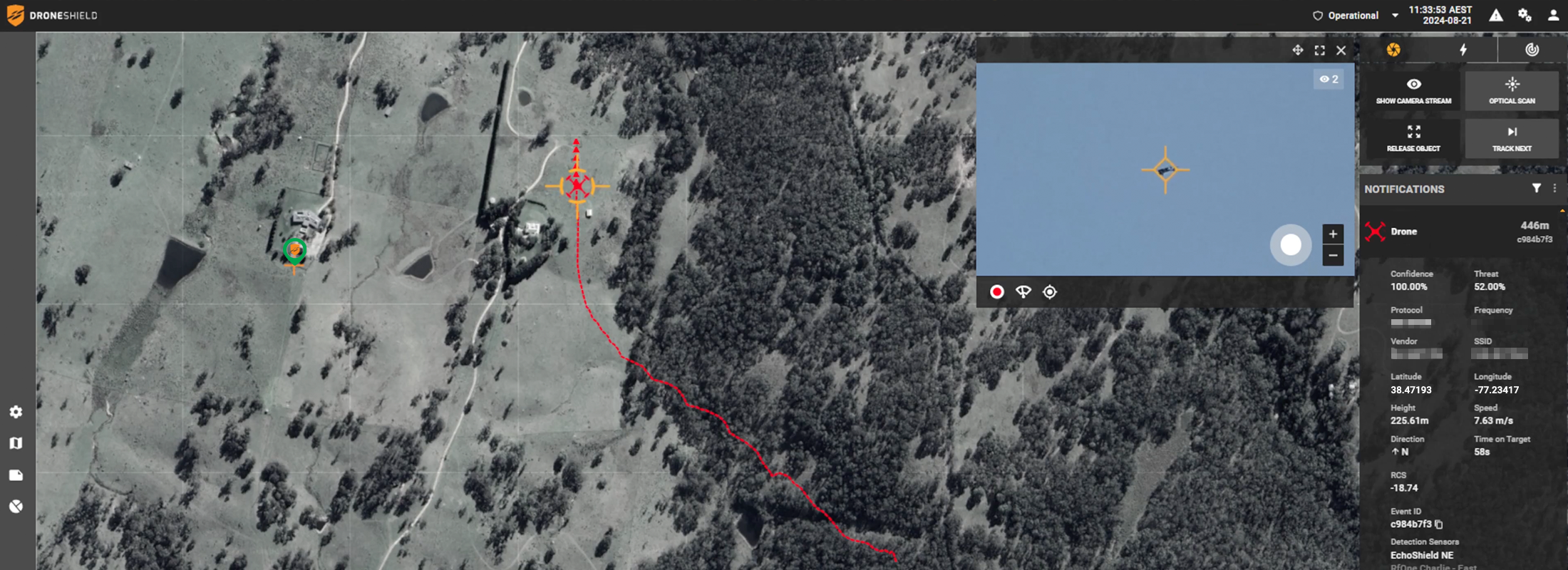
The GUI harnesses the advantages of each detection technology, providing the user with an early warning system and growing detection threat level as more data is gathered and processed.
DroneSentry-C2 allows for remote access to DroneShield products to check statuses, configure system settings, monitor threat levels and respond in real-time. DroneSentry-C2 is available in both cloud hosted and on-premises deployment options. Customers requiring maximum flexibility will benefit from secure cloud hosting, allowing multiple operators to manage sites remotely. Customers requiring an air-gapped solution benefit from the supplied on-premises 2RU server unit.
DroneSentry-C2 enables real time airspace awareness with a low cognitive burden to the system operator. It also acts as a Digital Twin, enabling virtual representation of the system’s physical sensor and effector assets, digitally overlaid to the required facilities, and providing simulation and training environment. It provides elements and dynamics of the system through its lifecycle to the end user.
DroneSentry-C2 has an optional Nearmap mapping upgrade for best-in-class mapping data. The upgrade supplements the existing mapping service provided with each DroneSentry-C2 license. Nearmap provides users with high resolution aerial imagery in Australia, New Zealand and North America. Nearmap’s resolution is several times higher than standard satellite imagery, providing increased precision when responding to C-UAS threats. Nearmap mapping data is regularly updated, ensuring sites reflect the latest geospatial data for operators.
System Components
System Components
Manage the Site from Anywhere
Secure cloud-based processing allows operators to access their sites from anywhere, anytime. Onsite or ‘air-gapped’ hardware solutions are also available.
Live Monitoring Dashboard
Live Dashboard allows operators to observe and understand the drone activity around their site immediately. Vast amounts of environmental data is processed and distributed to the operator only when required, in a form that is easy to understand, enabling the operator to make critical and swift decisions.
Detailed Evidence Collection
Statistics and logs of detections displayed in an easy to read summaries and can be exported for external use. Vendor, location, duration and MAC address of detections are displayed giving the users clear insight into activity within their airspace.
Engage Defeat Capabilities
Control and manage threats.
Digital Twin Planning Tool
Embedded planning tool allows for rapid planning of new site deployments to assess performance capabilities and ensure operational success in a visual real-world mirrored simulation. Existing sites can be saved and replicated into the platform to capture system deployment scenarios over its lifecycle.
MIL-STD-2525 Compliant Mode
Available in a MIL-STD-2525 version with industry leading enterprise features and MIL-STD-2525 compliance. As a sensor agnostic, open architecture platform, DroneSentry-C2 brings advanced interoperability and flexibility to users.
Advantages
Scalable & Flexible
Platform is built to scale horizontally and vertically, on-premise (air-gapped) or on cloud options are available. Can be used for single multi-sensor sites or several multi-sensor nodes working together
Immediate Evidence Collection
Displays live UAS (e.g. drone) activity, providing alerts to the user about the environment, inbuilt tools for detailed, precise report generation
Convenient
Can be accessed and configured remotely from a web browser, wherever there is Internet connectivity or as standalone desktop application. Air-gapped solutions also available. Alerts are configured through the GUI to send via SMS or Email for remote operators
Compatible
RESTful API allows easy integration into existing security systems
Software Locations
On-premises
Increased Security
| On-premises server allows for increased site security and control via an air-gapped network between sensors and processor. |
Package includes
| DroneSentry-C2 software |
| Mapping data |
| 2RU Server |
| Quarterly software updates |
Server Specifications
| Processor | Intel Xeon 2.30GHz 20 Core CPU |
|---|---|
| RAM | 32GB |
| Accelerated Signal Processing | NVIDIA Tesla T4 |
| TAA compliant server | |
Shipping and Installation
| Compatible with standard 19” rack systems | |
|---|---|
| Dimensions | Height 90mm (3.5”), Width 483mm (19”), Depth 590mm (23.2”) |
| Weight | 14.2kg (31.3lbs) |
Cloud-based
Increased Flexibility
| Cloud hosting caters to flexible deployment scenarios where internet accessibility is readily available. Not requiring physical hardware means setup time and complexity is reduced. |
Secure Site Management from Anywhere
| Cloud-based processing allows operators to securely access their sites from anywhere, anytime. |
Package includes
| DroneSentry-C2 software |
| Mapping data |
| Cloud hosting |
| Quarterly software updates |
Sensor Integrators
Geospatial Integrators
Case Studies
20 Nov 2023
Air Force Base
DroneShield deployed a DroneSentry detect and defeat system at Grand Forks Air Force Base. The deployment had multiple DroneSentry units around the large-scale site, forming a 360° integrated Counter Unmanned Aerial System (C-UAS) platform for long-range detection, classification, tracking, and defeat.
20 Nov 2023
IRONMAN Sports Event
Montgomery County Office of Homeland Security and Emergency Management (MCOHSEM) deployed DroneShield's DroneSentry System for the IRONMAN Triathlon Championships 2023 in Woodlands, Texas for the second year in a row.
1 Mar 2021
Australian Army
DroneShield has deployed the RfOne Mk2 on an Australian Army ASLAV for the 2021 Talisman Sabre military training exercise and for ongoing deployments. A total of three RfOne devices were deployed allowing the Australian Army to detect and track drones using RF intersection.
How to buy
See how to buy for more information on how to buy DroneShield Products.


